World's first! DJI drone completes test of material transportation to Everest Base Camp

Creates a record for civil drone transportation at up to 6,000 meters, assisting high-altitude mountaineering, rescue and environmental protection operations
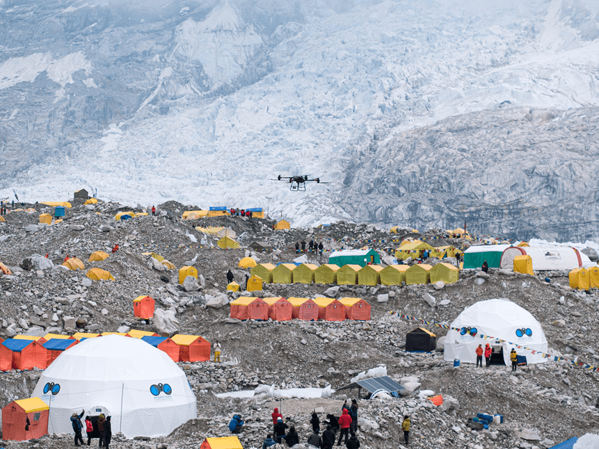
DJI announced today that it has conducted the first high-altitude drone transportation test on the south slope of Mount Everest. This is also the first round-trip transportation test of a transport drone on a route between 5,300 and 6,000 meters above sea level, setting a record for the highest transportation of a civilian drone.
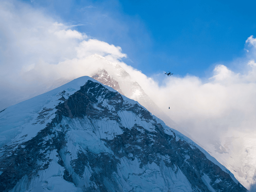
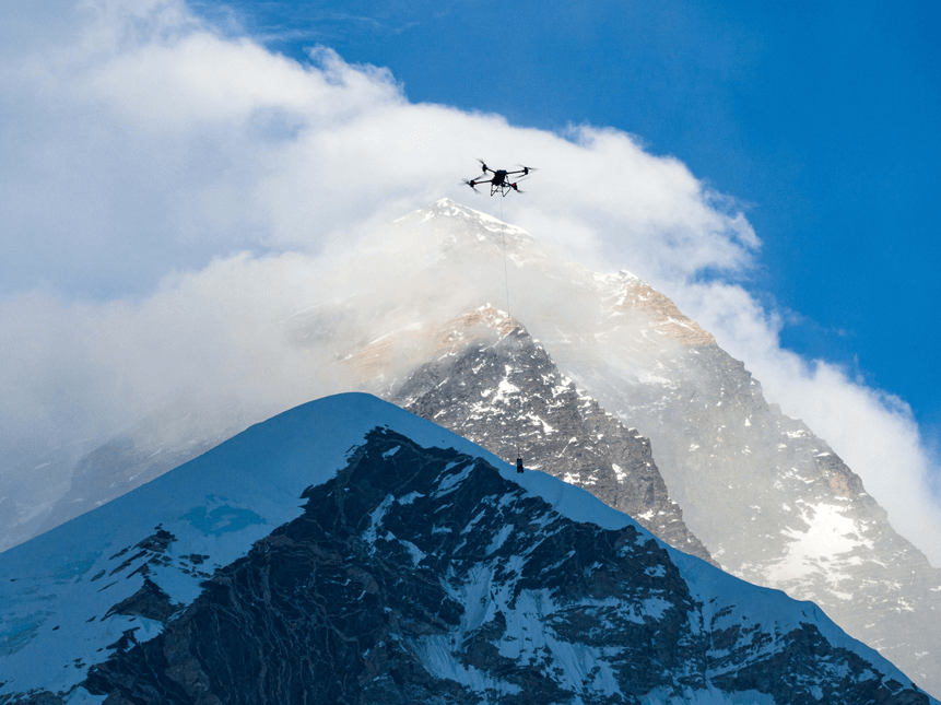
The latest test results highlight the stability of the DJI FlyCart 30 (FC30) transport drone in the 6,000-meter plateau area, as well as its ability to efficiently transport goods and remove garbage. The test shows that the FC30 can fly up to 6,191.8 meters in the Everest area, and can stably carry 15 kilograms at an altitude of 6,000 meters.
This actual test has accumulated real data and valuable experience for the next step of large-scale and normalized use. As a promoter of the wider application of drone delivery solutions, DJI is working with partners to promote the normalization of drone transportation in high-altitude areas to assist high-altitude mountaineering, emergency rescue and environmental protection actions.
FC30 completed the world's first drone Everest transportation test at an altitude of 6,000 meters with a load of 15 kg
DJI's FC30 delivery drone was officially launched in August 2023 and has been put into use in dozens of countries and regions around the world. The intelligent, safe, economical and efficient transportation solution has been recognized by users, helping users solve transportation problems in multiple scenarios such as mountains, shore-based, emergency, and logistics.
From April 25 to May 1 this year, engineers from DJI’s transport drone team overcame adverse conditions such as altitude sickness, a short climbing window, and complex and changeable climate and terrain, and conducted a week-long test of the drone’s high-altitude flight and transportation capabilities at the base camp on the south side of Mount Everest (5,300 meters above sea level) and above. They effectively verified the plateau adaptability of the drone’s hovering, empty flight, and cargo flight, and at the same time created a record for the highest flight altitude of a civil transport drone, at 6,191.8 meters, and a round-trip transportation record at an altitude of 6,000 meters with a load of 15 kilograms.
It has been verified that in the flight period with a temperature of minus 5℃ and a wind speed of 15 meters per second (equivalent to a force 7 wind), the FC30 can fly stably at an altitude of about 6,000 meters without any modification, and has a load capacity of 15KG; in the transportation mission with a load of 15 kilograms, a route length of 2.7 kilometers, and an altitude of 700 meters, there is still 43% of power left after a round trip, and the power margin is still more than 20% under extreme climbing conditions. The power system is stable and there is still room for ceiling.
It is reported that this is also the world's first drone transportation test completed in a natural environment at an altitude of 6,000 meters and under real mountaineering conditions. The test was initiated by DJI and assisted by Airlift, a Nepalese drone operating company, 8KRAW, a domestic professional imaging team, and Imagine Nepal Mountaineering Company. After solving a series of problems such as flight permits, equipment transportation, and route planning, the transportation test was successfully completed.
It is worth mentioning that FC30 has been optimized for various extreme scenarios during product design. In the just-concluded 40th Antarctic scientific expedition, FC30 also passed the test of the cold Antarctic climate and harsh environment on the flight performance of drones, and demonstrated stable flight capabilities and reliability, greatly improving the efficiency and flexibility of scientific expedition operations. Before the actual measurement in the Everest region began, an extreme survey and verification was also conducted at an altitude of 6,000 meters in Shigatse, Tibet.
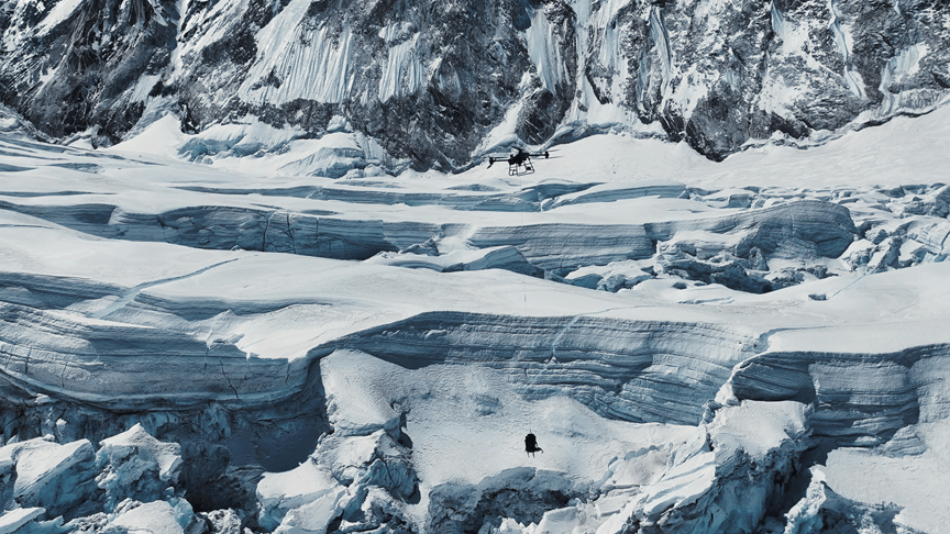
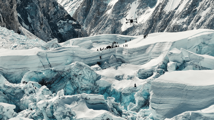
Flying over the highest "terrifying" icefall on earth, drones built a 2.7-kilometer air transportation channel
It is reported that the best window period for climbing Mount Everest from the Nepalese side is from the end of April to mid-May each year. In order to complete the on-site transportation measurement of FC30 within the window period and accumulate experience for normalized transportation, the DJI transportation team decided to focus on the transportation from the South Slope Base Camp to the C1 Camp this year, because this route has the highest icefall on earth-the Khumbu Icefall, which is the first major obstacle to climbing Mount Everest on the South Slope. It is also the most complex and dangerous section of the South Slope mountaineering geographical environment, also known as the "terrifying icefall".
"People often describe it as deadly and unpredictable." Mingma G, a well-known local mountaineering guide in Nepal, said that the Khumbu Icefall is in a complex situation with crisscrossing ice cracks. Almost every year, climbers and Sherpa guides die in the Khumbu Icefall. Especially Sherpa guides who mainly provide mountaineering assistance and transportation services may need to cross the Khumbu Icefall more than 30 times in a climbing season to complete the transportation of oxygen cylinders, gas tanks, tents, food, ropes and other materials. The high-risk working environment makes them, who are better adapted to the plateau, also face life safety challenges.
Although the Everest region has supported the use of helicopter transportation to reduce the number of material transportation, due to the altitude and weather, there are often situations such as untimely dispatch, inability to fly, inability to land or high costs. The carrier drone has obvious advantages in these aspects, providing a faster and more flexible solution for material transportation and emergency rescue.
Jiang Jianmin, an engineer at DJI, recalled that after a series of flight tests, including hovering at an altitude of 5,300 meters with no load, hovering at an altitude of 6,191 meters with no load, hovering at an altitude of 5,300 meters with a load of 10 kg, and hovering at an altitude of 6,000 meters with a load of 10 kg, the team began to "open up" an air transport route over the base camp on the south slope of Mount Everest. When the aircraft was empty, they searched for a point near Camp C1 above the Khumbu Icefall where people must pass without signal obstruction. After determining the target point, they completed the route planning and then hoisted 15 kg of mountaineering equipment (including 3 oxygen cylinders weighing 4.5 kg and 1.5 kg of scattered supplies) at a flight speed of 15 meters per second from the base camp across the Khumbu Icefall to the vicinity of Camp C1. They used the aerial hoisting system for one-button rappelling and the package was released after it touched the ground and picked up by ground personnel near the camp. Then they loaded the cargo in the air and mounted 15 kg of garbage for an intelligent return flight. The round trip took a total of 12 minutes with stable operation and 43% battery left.
Mingma G revealed that it takes an average of about 6-8 hours for Sherpa guides to cross the Khumbu Icefall, with a maximum load of 15 kilograms each time. If they are unlucky, they are likely to get into trouble. Last year, three Sherpa guides in his team died here. DJI's drone can deliver 15 kilograms of supplies between camps in just 12 minutes during the day or at night, which gives them a new way to reduce casualties. "The test results of drones on Mount Everest are very good. This means that soon, we can use drones to deliver equipment to Camp C1 day and night, and we can also use drones to transport all the remaining garbage and excrement from the upper camps. We don't have to cross the icefall frequently at night, and we don't have to endure the cold. It will definitely help save more lives." Partner Wang Yuanzong recalled that in high-altitude mountaineering activities, the use of oxygen is the choice of most people, and oxygen is also considered one of the most basic guarantees in the industry. When the drone successfully delivered 3 oxygen bottles for the first time and returned smoothly with the garbage, climbers from all over the world who stopped around the South Slope Base Camp collectively applauded and cheered.
The normalization of plateau transportation is accelerating, adding support to environmental protection and commercial mountaineering
In recent years, the high-altitude climbing industry has been developing in full swing, and the number of climbers around the world has increased. In addition to the safety and rescue issues of climbers, environmental pollution and other issues have also increased.
Taking the climbing of the south side of Mount Everest as an example, according to statistics from the Nepal Tourism Department, as of now, 414 climbers have obtained permits to climb from the south side in 2024. A large number of mountaineering activities have generated a huge amount of garbage, including human excrement, residual garbage that is difficult to degrade, etc. It is worth mentioning that all parties are also exploring better solutions to this problem.
Zhang Xiaonan, senior corporate strategy director and spokesperson of DJI, said that the fact that DJI's carrier aircraft can demonstrate its transportation value on Mount Everest is a recognition of its technology and products, but more importantly, it can obtain valuable flight parameters for ultra-high altitude areas, laying a more solid foundation for the use of this type of drone in plateau areas. She mentioned, "Today is World Environment Day. We hope that drones can not only provide material transportation guarantees for commercial mountaineering and reduce accidents; on the other hand, the garbage removal solution of drones can reduce the damage to the environment caused by mountaineering activities and protect Mount Everest and the natural environment."
The FC30 Everest transportation test broke the global 6,000-meter transportation record and is expected to provide new solutions for many commercial mountaineering projects around the world. According to the latest news, the application effect of FC30 in the Everest region has been highly recognized by local Nepalese authorities, commercial mountaineering organizations, and operating companies. Among them, the local operating company in Nepal has been commissioned by the local government of Nepal to go to the base camp on the south slope of Mount Everest on May 22 to officially start the normal transportation project of carrier drones in the Everest region. The main work includes cleaning up the residual garbage on the south slope of Mount Everest. The plan was one climbing season earlier than expected. In addition, DJI's domestic partners are also promoting the application of FC30 in more mature commercial mountaineering routes such as Mount Nama and Mount Gongga.
The accelerated implementation of regular transportation of transport drones in high-altitude areas may promote high-altitude mountaineering and rescue into a new era, and will also add impetus to environmental protection and the sustainable development of the mountaineering industry.
Related News


Contact US
Product Information
Quantity
Unit
Piece
Support order samples, customization, wholesale direct, and complete payment. If the product you look for does not have corresponding customized content, pls fill out the form below to contact us, and we will reply ASAP.