Technology
About This Company
Jiangsu Legend Intelligent Technology Co., Ltd. is a professional UAV industry application solution service provider. Relying on a perfect service system and a good cooperation mechanism, it has now become a deep cooperation partner of DJI industry applications.
Professional Team
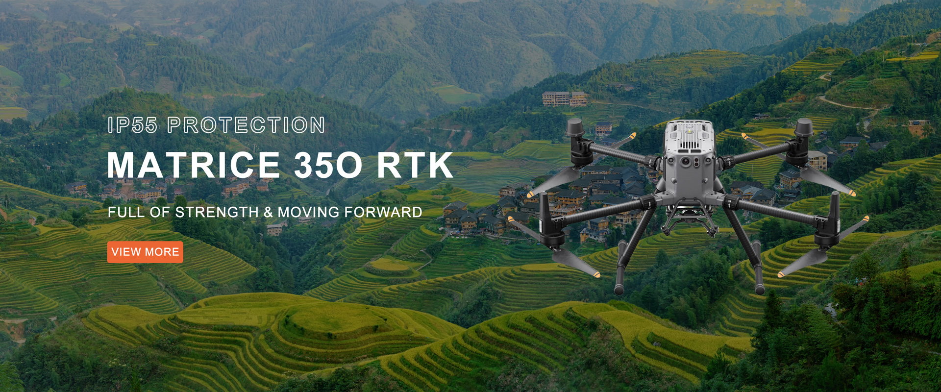
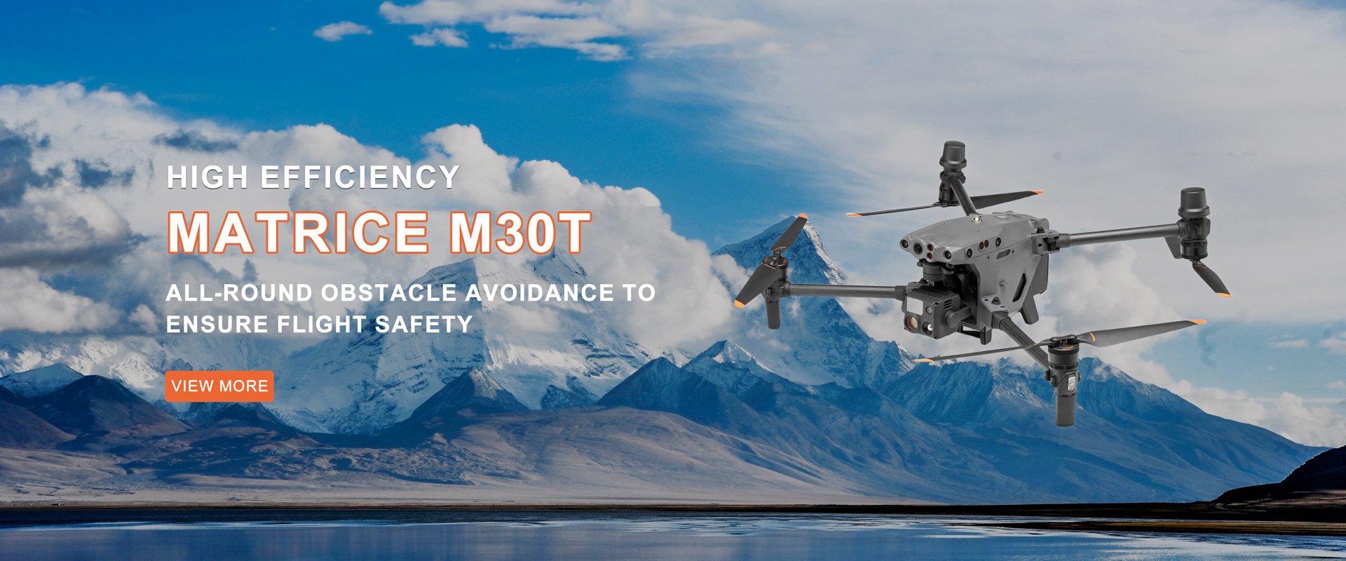
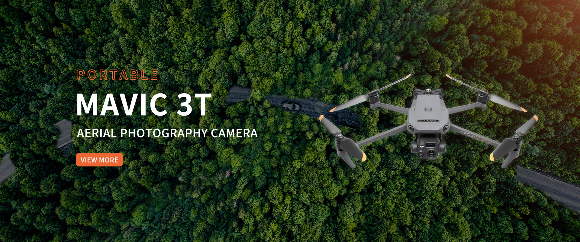
EXPLORE
Strong strength
EXPLOREProducts
HARMONIOUS COEXISTENCE WITH THE ENVIRONMENT


.jpg?x-oss-process=image/resize,w_299/quality,q_100)

.jpg?x-oss-process=image/resize,w_398/quality,q_100)
Video Display
Provide customers with multi-dimensional and comprehensive solutions from top-level design to implementation services
NEWS
LATEST NEWS


01-14-2025
DJI agricultural drones can manage corn in the middle and late stages, increasing yields by more than 10% per mu
(Tongliao, September 24, 2024) Recently, DJI Agriculture held a UAV corn yield measurement exchange meeting on "Promoting agricultural modernization, a new chapter in corn aerial defense" in Tongliao, Inner Mongolia. The event aims to explore how scientific and technological productivity represented by agricultural drones can participate in the mid- and late-stage plant protection management of corn under the guidance of national policies to achieve the feasibility of increasing production and income. More than 50 people attended the event, including domestic mainstream media, DJI Agriculture dealers, and large-scale growers. According to Cheng Zhongyi, an engineer of DJI Agricultural Solutions, traditional ground spraying equipment is prone to crushing seedlings, resulting in yield losses. If the operation is carried out after rain, it is also easy to sink into the field, and pests and diseases cannot be prevented in time. In the middle and late stages of corn, due to the high plants, traditional machinery and manual operations cannot be carried out, so most farmers often leave it alone. The average coverage rate of agricultural drones in corn is less than 20%. "In the early stage of corn planting, we usually use agricultural four-wheeled vehicles for spraying, but there will be the situation of crushing seedlings, which is inefficient and low in yield. In the later stage, when the plants grow taller, we will not spray pesticides, mainly because we couldn't spray them in the past." Zhao Hongcheng, a large grower in Tongliao City, said. "Air" management tool: drone corn flight spraying, increasing yield by more than 10% per mu Agricultural drones are not restricted by terrain, do not crush seedlings, and have good operation and stable image transmission. They can be used in the whole process of corn plant protection, which can effectively solve the problems of difficult application of pesticides in the middle and late stages of corn and poor prevention and control of pests and diseases, and avoid crop yield reduction. It is understood that the DJI Agriculture T60 agricultural drone has a capacity of 50 kg spraying load and 60 kg sowing load, and the efficiency of regular field operations can reach 1,000-1,200 acres a day. Facing tall corn crops, DJI's four-antenna O4 image transmission system can ensure smooth and stable images, and achieve a transmission distance of up to 2 kilometers. When the remote control signal is severely blocked, it can also automatically switch to a 4G data link, making the flight safer. In the face of windbreaks around the corn fields, DJI agricultural drones can also achieve RTK precision-level precision operations through flight marking, ensuring that the edges of the fields are not missed or re-sprayed, which is efficient and convenient. At the event, the DJI Agricultural Sales Team selected two corn fields of the same size, one for the aerial spraying test field and the other for the control field, to compare yields. The test field was sprayed twice, at the flaring stage and the tasseling stage; the control field was sprayed once at the beginning and no further management was done, in accordance with farmers' past habits. Finally, the yield and quality differences were compared by sampling and yield measurement. After weighing, the sample weight of the control plot was 6.93 kg, with an estimated yield of 1083.8 kg per mu; the sample weight of the test plot was 9.03 kg, with an estimated yield of 1211 kg per mu, a theoretical yield increase of 127.2 kg per mu compared with the control plot. Practice has proved that drone spraying of corn in the middle and late stages can increase corn production by more than 11.7%, effectively ensuring the timely prevention and control of pests and diseases, and thus ensuring increased corn production and income. Promote high-quality grain projects and safeguard food security According to data from the National Bureau of Statistics, the corn planting area in 2023 is 44,218.90 thousand hectares, accounting for about 37% of the grain crop planting area. Among all cereals, it is the crop with the largest planting area. With the strengthening of the economic value of corn and policy guidance, China's corn industry is gradually playing an increasingly important role in the world. In April 2024, the State Council officially issued the "Action Plan for Improving the Production Capacity of 100 Billion Jin of Grain (2024-2030)", which pointed out that the focus of capacity improvement is on corn and soybeans, emphasizing that "corn focuses on integrated matching and focusing on yield". At the same time, it insists on relying on science and technology, integrated matching, and promoting the combination of good fields and good systems, good varieties and good methods, and the integration of agricultural machinery and agronomy. In recent years, the country has introduced a number of policies to increase grain production capacity. Based on the increase in corn yield, in addition to good fields and good varieties, the most important thing is the mid- and late-stage pest and disease control and foliar nutrient spraying technology, that is, "one spray, multiple promotions", which points the way to improve the mechanized management level of corn in the mid- and late-stage. With the continuous advancement of China's agricultural science and technology, drone technology has become an important tool for completing this modern agricultural management link, and has also made mid- and late-stage corn operations possible. Zhang Yuan, global sales director of DJI Agriculture, said that from the full-process plant protection management of rice and wheat to the mid- and late-stage aerial defense application of corn, DJI Agriculture uses advanced drone technology to help farmers increase production and income on various crops, ensure food security, and promote the process of agricultural modernization. After more than ten years of hard work, DJI agricultural drones cover more than 100 countries and regions around the world, with a total of more than 300 crops, helping global agriculture solve operational problems. In the future, we will continue to gain insight into user pain points, make agriculture easier, and make life better.

07-24-2024
DJI drone technology helps forestry enter the stage of digital intelligent application
Recently, DJI, a global provider of civilian drone systems and solutions, and Yichun Forest Industry Dailing Forestry Bureau Co., Ltd. (hereinafter referred to as "Dailing Forestry Bureau") held an exchange meeting to explore the innovative practices of drone technology in forestry scenarios. The event attracted many media organizations to visit the Lesser Khingan Mountains forest area. Through field observations and interviews with industry users and the public, the media organizations learned about the importance of drones in forest fire prevention, emergency disaster relief, forest resource protection, etc., as well as how forest area staff can use technology to achieve modern forest protection and construction. At the event, Li Jiyong, director of the Forest Fire Prevention and Safety Supervision Department of Dailing Forestry Bureau, shared the situation and results of how foresters seized the opportunity of the times and relied on their own forest resources and technological advantages to do a good job in forest fire prevention and ecological protection. Yang Teng, director of the forestry industry of DJI, explained the necessity of the current forestry stage for new technologies, why DJI has entered the forestry field, and the cases and advantages of drone technology in forest fire prevention, pest control, and wildlife protection.In March last year, Dailing Forestry Bureau took the lead in introducing DJI Airport's automated patrol solution, which included 9 DJI Airports (including the Latitude M30T Airport Edition aircraft), planned nearly 100 regular patrol routes, and completed about 2,000 flight missions so far, with a total flight distance of nearly 10,000 kilometers.DJI Airports are deployed in 9 forest farm branches under the jurisdiction of Dailing Forestry Bureau and connected to the modern forestry management system. With the aerial technology advantages of drones, they effectively supplement the shortcomings of traditional patrol methods. At present, this "human-machine collaboration, air-ground complementarity" digital forestry patrol mode not only realizes normalized automated patrol operations in daily patrols, but also conducts all-round patrols of fire hazards, real-time monitoring of river flood conditions and road safety during special periods such as forest fire prevention and flood seasons, saving manpower while greatly improving the accuracy of patrols. Patrolmen over the Lesser Khingan Mountains, starting the forestry automated patrol mode my country's forest coverage rate is about 24%, with a forest area of 3.5 billion mu. Every day, more than 2 million forest rangers patrol the complex forest areas. However, traditional human patrol methods have many challenges in efficiency, accuracy and safety, and it is difficult to meet the needs of scientific management and ecological protection of forest resources.Northeast forestry is the country's most important forestry resource area. The Lesser Khingan Mountains run through the entire territory of Yichun. It is a national key state-owned forest area and a national key ecological functional area. Especially in the resource-rich Dailing, the total standing stock of living trees is 15.41 million cubic meters, and the forest coverage rate is 96%. There are more than 270 rare animals such as Chinese merganser and red deer.At the exchange event, Li Jiyong, director of the Forest Protection and Safety Supervision Department of Dailing Forestry Bureau, introduced that with the continuous development of science and technology, all walks of life are moving towards intelligent transformation. Dailing Forestry Bureau can provide a better view and fly farther through DJI drone patrols, and automated patrols can further liberate manpower. Li Jiyong introduced: "It used to take more than 2 hours for a patrolman to patrol 3 kilometers and 6 kilometers round trip. Now, drone patrols are used, and patrols are carried out every half an hour, which effectively improves the efficiency and frequency of patrols; drone patrols can also minimize the safety risks of staff, saving manpower while improving the accuracy of patrols." Yang Teng, director of DJI's forestry industry, said that DJI has always been committed to promoting the progress of human civilization, constantly pursuing technological innovation, and developing efficient, safe and easy-to-use drone technology solutions. Yang Teng said at the exchange event: "In 2016, DJI began to have in-depth contact with front-line personnel in forest farms and forestry bureaus to explore the feasibility of drone applications in forestry. With the establishment of DJI's industry application department, DJI has also successively launched industrial drones that meet industrial standards, visible light, lidar and other functional loads, as well as a more intelligent and automated DJI airport series. In 2023, the 9 airports deployed by the Xiaoxing'anling Yichun Forest Industry Dailing Forestry Bureau Company were the first case of forestry customers nationwide using DJI airports for automated forest patrols. Today, the new airport has also been upgraded to be smaller in size, longer in battery life, and more automated." "Technology helps forests", DJI provides the best solution for the industry At present, the "human-machine collaboration, air-ground complementarity" digital forestry patrol mode implemented by the Dailing Forestry Bureau of Yichun Forest Industry Group has provided an application sample for drone technology in forestry operations. Taking the Lesser Khingan Mountains forest area as an example, the total area of the Dailing Forestry Bureau is 96,742 hectares, of which 92,883 hectares are forest land, and the forest coverage rate is as high as 96%. The risks hidden in the vast forests are all observed by the naked eye, and it is easy to leave blind spots and blanks. New technologies can not only help front-line forest rangers reduce the risks of daily patrol operations, but also improve operational efficiency and prevent risks such as forest fires, pests and diseases, poaching and illegal logging.As global environmental and economic problems become increasingly severe, forests, as natural resources, play an increasingly important role in solving problems such as climate change, biodiversity reduction, and energy crisis. Humans are seeking more scientific and reasonable ways to develop and manage forest resources, and the advancement of science and technology has made this demand possible.Since its establishment, DJI's Industry Application Department has been committed to changing the way traditional industries work through drone technology. Today, DJI's industry drones are used in forestry systems such as large and small forest farms, municipal and county forestry bureaus, national parks, and nature reserves across the country. The core value of drone technology lies in its tool attributes. It prioritizes solving the practical problems and needs of front-line users, bringing intelligent productivity to front-line workers, reducing operational safety risks and improving operational efficiency. With the development and progress of technology, drones' autonomous control technology, networked communication technology and data processing capabilities have become increasingly intelligent and powerful. Visual imaging technology, infrared survey capabilities, more accurate LiDAR point clouds and intelligent target recognition algorithms have all made drone technology play an important role in daily forestry patrols, forest fire prevention, animal and plant protection, forestry resource surveys and other fields.In daily patrols, the use of the unmanned operation platform "DJI Airport" can achieve 24-hour all-weather automated inspections, and improve the real-time and accuracy of monitoring by sharing patrol conditions in real time. In forest fire prevention and flood control emergencies, high-altitude reconnaissance will be more efficient. Drones lock heat sources through infrared modules, and high-definition cameras monitor floods, providing valuable real-time information for fire fighting command and emergency rescue; in forest resource surveys, high-resolution cameras, LiDAR and other sensors are used, and software such as DJI Zhitu is analyzed to obtain multi-type three-dimensional high-precision models to meet the needs of forestry survey business. The National Forestry and Grassland Administration stated in its guidance on promoting the development of artificial intelligence in forestry and grassland that "(intelligent protection of ecosystems) should make full use of new-generation information technologies such as drones to realize intelligent ecological protection in the fields of forest ecosystem protection and grassland ecosystem protection."By applying "new quality productivity" to the forestry field, DJI is providing the forestry industry with safer, more efficient and more intelligent operation methods and solutions, while opening up new paths for the harmonious coexistence of humans and nature. From new quality productivity to promoting industry change, drone technology empowers thousands of industries This year, "new quality productivity" was written into the "Government Work Report" for the first time, and the cultivation of new quality productivity in all walks of life is in full swing. Heilongjiang Yichun Forest Industry Group Dailing Forestry Bureau Company took the lead in introducing drone technology to empower the forestry industry, which is a typical embodiment of the new quality productivity development strategy. At present, DJI's forestry customers are spread across many provinces and cities across the country, from Fujian and Guangxi in the south to Hunan, Hubei, Jiangxi in the middle, and then to forestry companies in the Greater and Lesser Xing'an Mountains in the north. The widespread application of drone technology in forestry systems such as large and small forest farms, municipal and county forestry bureaus, national parks, and nature reserves demonstrates its great potential in improving forestry management efficiency and productivity.In today's rapidly developing technological era, DJI drones are no longer just tools for aerial photography and entertainment, but have become pioneers in the transformation of many traditional industries. In Ganzhou, the birthplace of navel oranges, drones are responsible for the refined management of orchards in hilly terrain; on the island of Pingtan in Fuzhou, drones have ushered in the "unmanned inspection era" of power grids; in the Mianshan Scenic Area in Shanxi, drones use digital technology to protect the cultural heritage of ancient buildings; on the 6,000-meter Mount Everest, drones completed the world's first high-altitude material transportation... Drones have become an important role in many fields such as agricultural and forestry plant protection, emergency rescue, police patrols, cultural relics protection, and power inspections. From precise agricultural assistance to rural revitalization, from ensuring energy security to serving the dual carbon goals, from ecological and environmental protection to supporting the construction of a national modern emergency rescue system and other policy responses, DJI is accelerating the empowerment of thousands of industries with advanced industry drone solutions, and popularizing drone technology to all walks of life through cost-effective and high-quality products and services. It continues to provide intelligent application solutions and services for many basic and important industries, promote industry efficiency improvement and productivity transformation, and promote sustainable social and economic development.

11-25-2024
DJI Agriculture launches T100 and T70 series agricultural drones
(Shenzhen, November 25, 2024) DJI Agriculture officially released three agricultural drones in the T100 and T70 series. The flagship T100 agricultural drone is the most efficient agricultural drone in DJI Agriculture's history, with the largest rated takeoff weight and the most advanced safety system. It comprehensively improves efficiency and meets the needs of more scenarios. The new T70 series agricultural drone combines cost-effectiveness with multi-scenario and stability to lower the entry threshold. This new product launch aims to meet the needs of all user types and all operating scenarios. It is reported that this year marks the twelfth year that DJI has entered the agricultural field. With the launch of new products, DJI Agriculture has once again refreshed the flagship standard for the industry. "DJI Agriculture has always been adhering to the mission and vision of making agriculture easier and life better. It provides users with safe, worry-free, affordable and reliable products and timely and thoughtful after-sales service. Now DJI Agriculture has advanced technology, training and after-sales service. A complete support system has been established. With the expansion of the industry and the increase in user demand, DJI Agriculture will continue to provide advanced and reliable solutions for agriculture, forestry, animal husbandry and fishery scenarios." said Shen Xiaojun, head of DJI Agriculture's global market. T100 Agricultural Drone: Fully Loaded New Flagship T100 is DJI Agriculture’s first flagship agricultural drone equipped with AI and AR functions, with a maximum take-off weight of 149.9 kg. With 75 litre spraying capacity and 150 litre spreading capacity and 85 kg lifting capacity. It adopts a coaxial twin-rotor configuration, 62-inch carbon fiber blades, powerful power, a maximum single-axis thrust of 82 kg, and can achieve a maximum flight speed of 13.8 meters per second. This means that no matter the load capacity, configuration or performance, it has reached the fully loaded flagship standard. Fully loaded with flagship safety systems, the more you fly, the safer you become In order to cope with the complex farmland environment and ensure the safety of pilots and people and vehicles around them, T100 has upgraded its safety system to the "top configuration". Equipped with a new laser radar and active phased array radar, it can sense and accurately identify surrounding obstacles in all directions. The density of the spatial point cloud captured by the laser radar can reach 300,000 per second, which can accurately depict the boundaries of obstacles, effectively improve the recognition rate of inclined wires and wires, and take in all small obstacles in the field. With the new five-eye fisheye vision system, it can perceive the environment in real time at 360 degrees, and issue real-time warnings through the remote control to ensure takeoff safety. During the operation, the surrounding obstacles are observed in real time and the obstacle screen in any flight direction can be automatically displayed. The new AI algorithm can automatically identify obstacles encountered during operation and save the information of the plot, improve the efficiency of the same plot operation, and make it safer and safer. At the same time, this year, an AR safety assistance function has been added to detect people and cars around during takeoff and landing, and remind pilots to pay attention to the surrounding environment in time. AR flight trajectories can also be generated during operation to help pilots predict the flight direction of the aircraft. A safe landing projection is added during return to ensure the stability of landing. The new AI and AR functions fully guarantee safety and avoid accidental injuries.In addition, T100 continues the free aerial survey function, which can achieve a maximum 90-degree mountain climb, meeting the operation needs of most orchards. Spraying and sowing, outstanding efficiency and excellent results Spraying pesticides is the most common use of agricultural drones. The T100 has a spraying load of 75 kg, and the maximum flow rate of the dual nozzles is increased to 30 liters per minute. The droplet size is adjustable from 50 to 500 microns, which can meet the large flow operation scene without additional configuration.For users who need to work with thick canopies of fruit trees, four water-cooled mist nozzles are available as an option, with a flow rate of up to 40 liters per minute. The dual-motor water-cooling structure is durable, the droplet size can be as fine as 10 microns, the droplets are uniform and fine, the working efficiency is outstanding, and the effect is excellent. In terms of spreading, the T100 spreading system has a capacity of 150 liters and can spread two bags of fertilizer at a time. With the new generation of spiral auger, the flow rate doubles to 400 kg per minute, and the torque of the auger motor doubles, supporting high-speed spreading, and the overall operating efficiency is increased by 70%. Four types of auger can be replaced, suitable for a variety of particles, and the spreading is more accurate. Good helper for agricultural lifting Facing the transportation needs in agriculture, forestry, animal husbandry and fishery scenarios, T100 can also be transformed into a lifting expert. The lifting load is 85 kg, which can carry more and transport farther. During the flight, the three-way force sensor can intelligently adjust the posture, automatically eliminate the swing of the goods, and ensure smooth transportation.T100 supports setting the "loading" and "unloading" points on the mobile phone. The remote control can display the location of the destination point in real time through AR. Manual transportation can quickly find the loading and unloading points, and automatic flight is worry-free and efficient. It can also support weight detection to avoid overweight and facilitate settlement. 9-minute fast charging, economical and energy-saving In order to provide stable and continuous energy supply, the new intelligent flight battery has more power and lighter weight. Energy heat dissipation has always been a difficult problem in the industry. How to ensure the safety and stability of energy on the basis of effective heat dissipation is another difficult problem that DJI Agriculture has overcome this year. This year's newly designed three-air duct design dissipates heat from the battery through the flow channel design, ensuring that the energy is safe and stable, and truly achieving safe heat dissipation and heat dissipation while flying.With the D14000iE all-purpose variable frequency charging station, it can be charged at a very fast speed of 9 minutes, reduce fuel consumption, and effectively save operating costs. There is also a new on-board charger, which is silent and environmentally friendly. T70 series agricultural drones: strong and affordable The new T70 series also meets a variety of operating scenarios such as spraying, sowing, and lifting.The DJI T70 agricultural drone has been upgraded with a spraying load of 50 kg and a sowing load of 70 kg. The T70P is also equipped with a 70-liter medicine box and a 41-Ah long-life battery, with further upgrades in medicine loading and battery life, greatly improving efficiency.In terms of safety systems, the T70 series is equipped with a three-eye vision system and front and rear active phased array radars, and also integrates new AI and AR functions to ensure the safety of aircraft takeoff and landing and operations, and avoid accidental injuries. The AI algorithm can automatically identify obstacles encountered during operations and save the information in the plot, improve the efficiency of operations in the same plot, and fly more safely. The newly added AR safety assistance function detects people and cars around during takeoff and landing, and promptly reminds pilots to pay attention to the surrounding environment. AR flight trajectories can also be generated during operations to help pilots predict the direction of the aircraft's flight. When returning, the return point can be displayed in AR to quickly find the return direction. When landing, there is a safe landing projection to assist in checking the environmental safety on the landing route. The T70 series can carry a load of 65 kg and also supports setting the "loading" and "unloading" points on the phone. The remote control can display the destination location in real time through AR. Manual transportation can quickly find the loading and unloading points, and automatic flight is worry-free and efficient. It can also support weight detection to avoid overweight and facilitate settlement. In terms of energy, the T70 series batteries have higher energy density, are lighter, support two-power cycles, and can fly as soon as they land. Through further optimization of the power system, energy consumption is further reduced under the same operating area and operating results. One flight can save 25% of electricity and 25% of fuel costs per day, resulting in lower operating costs. DJI Agriculture leads the industry standards and continues to provide users with full-link services "This year marks the twelfth anniversary of DJI Agriculture. DJI Agriculture has been committed to providing users with a full-link service support system from training, products to after-sales. We hope to use DJI's technology and resources to create a "worry-free entry" for users. , easy to use, worry-free to use, and reliable after-sales service standards. ” said Xiaojun Shen, head of global market at DJI Agriculture. 20% down payment, easy pick up This year, the threshold for users to purchase a machine has been lowered again. The interest rate of the "Pilot Loan" launched by DJI Agricultural Union Bank has been reduced to 3.2%. With a down payment of 20%, users can easily take the machine home, and the repayment method is flexible. Users can use DJI Agricultural service can apply. Help users purchase agricultural drones with a lower threshold, increase employment opportunities for returning home to start businesses, and reduce startup capital.

10-28-2024
Dozens of drones observe 24 hours a day! High-definition infrared + laser positioning to protect Asian elephants
Urgent! Save this elephant. "Recently, an Asian elephant weighing 2.5 tons fell into an abandoned pool in Xishuangbanna, Yunnan, struggling desperately but unable to save itself. In the critical moment, the rescue team quickly called in an excavator to break a gap, and used drones to observe the condition of the Asian elephant from high altitude and guide the excavator's operation. After the rescue, the drone continued to track and observe from a long distance to confirm the physical condition of the Asian elephant until it reunited with the elephant herd and returned to the reserve. In the emergency rescue of Asian elephants, the high-definition images taken by drones provided important support for the rescue. In the daily management of Asian elephants, relevant units in Xishuangbanna introduced dozens of drone equipment, including DJI Airport 2 and DJI M350 RTK equipped with Zenmuse H30T, using laser dot positioning, infrared and other functions to monitor Asian elephants in a scientific way and protect the elephant herd. Drone laser spotting to confirm elephant herd location More than 300 Asian elephants are scattered Tracking is difficult and risky Asian elephants are the largest terrestrial mammals in Asia and are also first-class protected animals in China. Currently, there are only more than 300 Asian elephants left, distributed in Xishuangbanna Dai Autonomous Prefecture, Pu'er City and Lincang City in the southern border area of Yunnan. In recent years, the Asian elephant population has continued to spread outward, and they frequently enter fields and villages to forage, causing economic losses and threats to the personal safety of villagers.It is difficult and risky for monitoring personnel to track Asian elephants in the wild. In order to ensure the safety of humans and elephants, the management department uses DJI industry drones to monitor the movements of elephants around the clock and issue early warnings to avoid conflicts between humans and elephants. Drones detected elephants wandering outside villagers’ homes. Staff promptly reminded villagers to evacuate. Accurate observation even at a distance Zenmuse H30T protects Asian elephants around the clock As a "giant" on land, Asian elephants are somewhat aggressive and need to be monitored and tracked in a safe and non-interference environment. The Zenmuse H30T zoom camera has a pixel of up to 40 million and a maximum zoom ratio of 400 times. Even at an altitude of 120 meters and 800 meters away from Asian elephants, it can clearly record the activities of Asian elephants. Zenmuse H30T captures elephants crossing a river In the tropical rainforest reserve where Asian elephants live, the trees are dense, making it difficult for elephants' ground activities to be captured by high-altitude visible light images. Using the Zenmuse H30T infrared ultra-clear mode, you can quickly spot Asian elephants through the gaps in the tree canopy. Visible light makes it difficult to spot Asian elephants hiding under trees infrared cameras can quickly identify them At night, Asian elephants are active frequently, which is the main time for monitoring. In the complex environment of the forest, the operator turns on the full-color night vision mode of the Zenmuse H30T to see the terrain around the drone and ensure flight safety. In addition, through high-resolution infrared thermal imaging, the every move of the Asian elephants can be clearly observed, achieving all-weather protection. Zenmuse H30T infrared camera spotted Asian elephants at night Drones monitor elephant activities 24/7 and perform location tracking to obtain the precise distance between drones and elephants and the exact location of the elephants in real time, thus ensuring a safe boundary between drones and elephants. Using the laser dot function of drones to locate elephant herds Once elephants are found moving near residential areas, staff will immediately release relevant information through the early warning platform and remind residents to pay attention to safety and evacuate villagers in time to ensure their lives. The Asian Elephant Warning App marks the location of people and elephantsVillagers can obtain warning information in a timely manner Last July, a drone infrared camera captured a herd of elephants walking to a restaurant, less than 100 meters from the road. The staff immediately used the drone to shout warnings, reminding nearby farmers to stop working and that the road was closed. For five consecutive days, the staff kept a close eye on the elephants' movements throughout the day. The drone flew more than 60 times, covering more than 300 kilometers, and found a total of 43 elephants, ensuring the safety of people and elephants. Autonomous patrol, regular data updates DJI Airport 2 assists elephant research During daily patrols, staff use drones to carry out mobile operations. In areas where Asian elephants are active, the management center has deployed two DJI Airport 2s, which eliminates the need for personnel to go deep into the site, reducing the difficulty and risk of field monitoring personnel tracking Asian elephants. Staff planned a nearly 6-kilometer autonomous patrol mission for DJI Airport 2, and the drone took off autonomously to send back high-definition live broadcast images. Plan patrol routes in the DJI SKY2 backend Asian elephants do not have fixed homes and their activities are random. When an emergency occurs, the staff can remotely take over through the DJI Skylon 2, control the drone to quickly fly to the destination for inspection, and help the team understand the situation on the scene in a timely manner. Operators remotely operate drones to film the activities of Asian elephants At the same time, the staff used DJI Airport 2 to regularly photograph and locate elephant herds, scientifically counted the frequency of appearance of Asian elephants, and refined their main activity areas, providing an important basis for understanding the number and status of Asian elephant populations, and further investigating, studying and protecting Asian elephants. The locations where Asian elephants frequently appear have been marked UAVs have become an indispensable part of the protection of Asian elephants. Based on the UAV system, Yunnan Province has established a monitoring system that combines drones, ground cameras and ground personnel, and built a monitoring platform, an early warning platform and a command platform, realizing 24-hour online monitoring of Asian elephants, real-time push and full coverage of early warning information, protecting the safety of elephants and surrounding people, and promoting harmonious coexistence between man and nature.

01-12-2025
Drone Suppliers: How to maintain and service drones?
Maintenance and care of your DJI Drone are essential to extend its lifespan, ensure flight safety, and improve flight performance. Here are some tips and steps for drone maintenance and care: 1. Regularly check the hardware 1.1 BatteryBattery status check: Regularly check the battery for swelling, leakage, overheating, or other physical damage. If any problems are found, replace the battery immediately.Monitor while charging: Use the original charger and avoid overcharging. The battery should not be left unattended for too long while charging.Storage Note: When the drone is not used for a long time, it is recommended to charge the battery to 40%-60% of its capacity and store it in a cool and dry place. Avoid storing the battery after it is fully discharged.Temperature control: Avoid using or storing the battery at too high or too low temperatures. Both high and low temperatures will affect the performance and life of the battery.1.2 PropellersPropeller inspection: Regularly check the propellers for cracks, deformation, scratches, or other damage. Damaged propellers will affect flight stability and may even cause the drone to lose control.Propeller cleaning: Clean dust, sand, and other debris from the propellers to ensure that the propellers are balanced. You can use a soft cloth and appropriate cleaning fluid to wipe the propeller.1.3 Motor and SensorMotor Cleaning: After long-term use, the motor may accumulate dust and debris, which may affect its performance. Check the motor regularly to ensure that the motor is not blocked and clean the debris on the surface of the motor.Sensor Check: Regularly check whether the GPS, gyroscope, accelerometer, compass and other sensors are working properly. Perform necessary sensor calibration, especially when the flight environment changes (such as the flight site changes).1.4 Flight Control System (FCU)Flight Control System Update: Check and ensure that the firmware of the Flight Control System (FCU) is the latest version. Regularly check the flight control system to confirm that it has no faults or abnormal working conditions. 2. Regular Flight Checks 2.1 Pre-flight CheckCheck the overall structure of the aircraft: Make sure that the structure of the drone is intact and there are no loose screws or parts. Check whether the gimbal, camera and other additional equipment are firmly connected.Battery power of the aircraft: Make sure the battery is sufficient before each flight to avoid loss of connection during flight due to insufficient battery. It is generally recommended to charge the battery to 80%-100% before flight.Check GPS signal: Check whether the GPS signal is strong before flight to ensure the stability of the positioning system and avoid losing positioning during flight.2.2 In-flight monitoringReal-time monitoring of flight data: Monitor the flight status of the drone in real time through the remote control or mobile phone application, such as battery power, flight altitude, speed, GPS signal, etc., and take timely measures to avoid problems.Avoid excessive flying: Avoid flying for too long, especially when the battery power is low. High-load flight will accelerate battery aging.2.3 Post-flight inspectionPost-flight cleaning: Clean the drone after flight, especially parts such as motors, propellers, sensors and gimbals. Clean dust, sand and moisture to ensure that the device is in a dry state.Check battery power: Check the battery power after flight and charge or store it as needed. Avoid leaving the battery fully charged or fully discharged for a long time. 3. Firmware and software updates Firmware updates: Regularly check the firmware version of the drone and remote control to ensure that the software is up to date. Drone manufacturers usually release new firmware updates to improve performance or fix vulnerabilities.Calibration and configuration: Regularly calibrate sensors, especially compass and GPS. If the drone has problems such as unstable flight or drift, recalibrating the sensor can help solve the problem. 4. Preventing damage and collisions 4.1 Avoid areas with high collision risksAvoid flying in crowded places: Try to avoid flying in crowded areas to reduce the risk of accidents.Flight environment selection: Avoid flying in extreme weather conditions such as strong winds, rain, snow, lightning, etc. to avoid damage. It is best to choose an unobstructed, open field for flying.4.2 Use protective accessoriesProtective cover: If you are a beginner or worried about collisions, using a protective cover (such as a propeller cover) can help protect the drone from damage.Landing mat: Using a landing mat can protect the bottom of the drone and reduce damage to the battery and sensors. 5. Storage and transportation 5.1 Drone storageAvoid high temperature environment: Avoid storing the drone for a long time in a high temperature environment, especially the battery. High temperature can damage the battery and shorten its life. The ideal storage temperature is usually between 20°C-25°C.Store in a dry environment: Store the drone in a dry environment to avoid damage to the device caused by a humid environment.Removing the battery: When not in use for a long time, remove the battery and store it properly to prevent the battery from being in a charged state for a long time or over-discharging.5.2 Transporting the droneUsing a special bag: If you need to carry a drone, it is best to use a special drone bag for protection. This can avoid collision or damage to the drone during transportation.Pay attention to protecting the propellers and sensors: When transporting the drone, make sure the propellers are properly fixed to avoid damage due to vibration or external force. 6. Dealing with failures If you encounter problems such as unstable flight, abnormal battery power, sensor failure, etc., first check whether all hardware is normal. If it is a software failure, try to restart the device or restore the factory settings.Professional maintenance: If the drone has an unrepairable problem, contact the manufacturer or a professional maintenance point in time for inspection and repair to avoid self-disassembly that may cause more serious damage. SummaryRegularly checking the drone's hardware, sensors, flight systems, etc., and performing necessary cleaning and maintenance will help ensure the long-term stability and flight safety of the drone. At the same time, proper battery maintenance, firmware updates, and flight environment selection can effectively extend the service life of the drone and reduce the probability of failure. With proper care and maintenance, your drone can better serve your flight missions and provide more stable and reliable performance.
11-25-2024
DJI Agriculture launches T100 and T70 series agricultural drones
(Shenzhen, November 25, 2024) DJI Agriculture officially released three agricultural drones in the T100 and T70 series. The flagship T100 agricultural drone is the most efficient agricultural drone in DJI Agriculture's history, with the largest rated takeoff weight and the most advanced safety system. It comprehensively improves efficiency and meets the needs of more scenarios. The new T70 series agricultural drone combines cost-effectiveness with multi-scenario and stability to lower the entry threshold. This new product launch aims to meet the needs of all user types and all operating scenarios. It is reported that this year marks the twelfth year that DJI has entered the agricultural field. With the launch of new products, DJI Agriculture has once again refreshed the flagship standard for the industry. "DJI Agriculture has always been adhering to the mission and vision of making agriculture easier and life better. It provides users with safe, worry-free, affordable and reliable products and timely and thoughtful after-sales service. Now DJI Agriculture has advanced technology, training and after-sales service. A complete support system has been established. With the expansion of the industry and the increase in user demand, DJI Agriculture will continue to provide advanced and reliable solutions for agriculture, forestry, animal husbandry and fishery scenarios." said Shen Xiaojun, head of DJI Agriculture's global market. T100 Agricultural Drone: Fully Loaded New Flagship T100 is DJI Agriculture’s first flagship agricultural drone equipped with AI and AR functions, with a maximum take-off weight of 149.9 kg. With 75 litre spraying capacity and 150 litre spreading capacity and 85 kg lifting capacity. It adopts a coaxial twin-rotor configuration, 62-inch carbon fiber blades, powerful power, a maximum single-axis thrust of 82 kg, and can achieve a maximum flight speed of 13.8 meters per second. This means that no matter the load capacity, configuration or performance, it has reached the fully loaded flagship standard. Fully loaded with flagship safety systems, the more you fly, the safer you become In order to cope with the complex farmland environment and ensure the safety of pilots and people and vehicles around them, T100 has upgraded its safety system to the "top configuration". Equipped with a new laser radar and active phased array radar, it can sense and accurately identify surrounding obstacles in all directions. The density of the spatial point cloud captured by the laser radar can reach 300,000 per second, which can accurately depict the boundaries of obstacles, effectively improve the recognition rate of inclined wires and wires, and take in all small obstacles in the field. With the new five-eye fisheye vision system, it can perceive the environment in real time at 360 degrees, and issue real-time warnings through the remote control to ensure takeoff safety. During the operation, the surrounding obstacles are observed in real time and the obstacle screen in any flight direction can be automatically displayed. The new AI algorithm can automatically identify obstacles encountered during operation and save the information of the plot, improve the efficiency of the same plot operation, and make it safer and safer. At the same time, this year, an AR safety assistance function has been added to detect people and cars around during takeoff and landing, and remind pilots to pay attention to the surrounding environment in time. AR flight trajectories can also be generated during operation to help pilots predict the flight direction of the aircraft. A safe landing projection is added during return to ensure the stability of landing. The new AI and AR functions fully guarantee safety and avoid accidental injuries.In addition, T100 continues the free aerial survey function, which can achieve a maximum 90-degree mountain climb, meeting the operation needs of most orchards. Spraying and sowing, outstanding efficiency and excellent results Spraying pesticides is the most common use of agricultural drones. The T100 has a spraying load of 75 kg, and the maximum flow rate of the dual nozzles is increased to 30 liters per minute. The droplet size is adjustable from 50 to 500 microns, which can meet the large flow operation scene without additional configuration.For users who need to work with thick canopies of fruit trees, four water-cooled mist nozzles are available as an option, with a flow rate of up to 40 liters per minute. The dual-motor water-cooling structure is durable, the droplet size can be as fine as 10 microns, the droplets are uniform and fine, the working efficiency is outstanding, and the effect is excellent. In terms of spreading, the T100 spreading system has a capacity of 150 liters and can spread two bags of fertilizer at a time. With the new generation of spiral auger, the flow rate doubles to 400 kg per minute, and the torque of the auger motor doubles, supporting high-speed spreading, and the overall operating efficiency is increased by 70%. Four types of auger can be replaced, suitable for a variety of particles, and the spreading is more accurate. Good helper for agricultural lifting Facing the transportation needs in agriculture, forestry, animal husbandry and fishery scenarios, T100 can also be transformed into a lifting expert. The lifting load is 85 kg, which can carry more and transport farther. During the flight, the three-way force sensor can intelligently adjust the posture, automatically eliminate the swing of the goods, and ensure smooth transportation.T100 supports setting the "loading" and "unloading" points on the mobile phone. The remote control can display the location of the destination point in real time through AR. Manual transportation can quickly find the loading and unloading points, and automatic flight is worry-free and efficient. It can also support weight detection to avoid overweight and facilitate settlement. 9-minute fast charging, economical and energy-saving In order to provide stable and continuous energy supply, the new intelligent flight battery has more power and lighter weight. Energy heat dissipation has always been a difficult problem in the industry. How to ensure the safety and stability of energy on the basis of effective heat dissipation is another difficult problem that DJI Agriculture has overcome this year. This year's newly designed three-air duct design dissipates heat from the battery through the flow channel design, ensuring that the energy is safe and stable, and truly achieving safe heat dissipation and heat dissipation while flying.With the D14000iE all-purpose variable frequency charging station, it can be charged at a very fast speed of 9 minutes, reduce fuel consumption, and effectively save operating costs. There is also a new on-board charger, which is silent and environmentally friendly. T70 series agricultural drones: strong and affordable The new T70 series also meets a variety of operating scenarios such as spraying, sowing, and lifting.The DJI T70 agricultural drone has been upgraded with a spraying load of 50 kg and a sowing load of 70 kg. The T70P is also equipped with a 70-liter medicine box and a 41-Ah long-life battery, with further upgrades in medicine loading and battery life, greatly improving efficiency.In terms of safety systems, the T70 series is equipped with a three-eye vision system and front and rear active phased array radars, and also integrates new AI and AR functions to ensure the safety of aircraft takeoff and landing and operations, and avoid accidental injuries. The AI algorithm can automatically identify obstacles encountered during operations and save the information in the plot, improve the efficiency of operations in the same plot, and fly more safely. The newly added AR safety assistance function detects people and cars around during takeoff and landing, and promptly reminds pilots to pay attention to the surrounding environment. AR flight trajectories can also be generated during operations to help pilots predict the direction of the aircraft's flight. When returning, the return point can be displayed in AR to quickly find the return direction. When landing, there is a safe landing projection to assist in checking the environmental safety on the landing route. The T70 series can carry a load of 65 kg and also supports setting the "loading" and "unloading" points on the phone. The remote control can display the destination location in real time through AR. Manual transportation can quickly find the loading and unloading points, and automatic flight is worry-free and efficient. It can also support weight detection to avoid overweight and facilitate settlement. In terms of energy, the T70 series batteries have higher energy density, are lighter, support two-power cycles, and can fly as soon as they land. Through further optimization of the power system, energy consumption is further reduced under the same operating area and operating results. One flight can save 25% of electricity and 25% of fuel costs per day, resulting in lower operating costs. DJI Agriculture leads the industry standards and continues to provide users with full-link services "This year marks the twelfth anniversary of DJI Agriculture. DJI Agriculture has been committed to providing users with a full-link service support system from training, products to after-sales. We hope to use DJI's technology and resources to create a "worry-free entry" for users. , easy to use, worry-free to use, and reliable after-sales service standards. ” said Xiaojun Shen, head of global market at DJI Agriculture. 20% down payment, easy pick up This year, the threshold for users to purchase a machine has been lowered again. The interest rate of the "Pilot Loan" launched by DJI Agricultural Union Bank has been reduced to 3.2%. With a down payment of 20%, users can easily take the machine home, and the repayment method is flexible. Users can use DJI Agricultural service can apply. Help users purchase agricultural drones with a lower threshold, increase employment opportunities for returning home to start businesses, and reduce startup capital.
Contact US
Product Information
Quantity
Unit
Piece
Support order samples, customization, wholesale direct, and complete payment. If the product you look for does not have corresponding customized content, pls fill out the form below to contact us, and we will reply ASAP.